

Exploring the wilderness is an enriching experience that allows individuals to immerse themselves in the natural world, away from the hustle and bustle of urban life. It offers a chance to witness breathtaking landscapes, encounter diverse wildlife, and enjoy the tranquility that only nature can provide. However, venturing into remote and rugged environments also comes with inherent challenges that require careful planning, navigation, and communication to ensure safety and success.
The Challenges of Wilderness Exploration
Navigational Difficulties
One of the primary challenges in wilderness exploration is navigation. Unlike urban environments, the wilderness lacks clear markers and paths, making it easy to become disoriented. Dense forests, mountainous terrains, and vast deserts can obscure landmarks and make it difficult to maintain a sense of direction. Accurate navigation is crucial to avoid getting lost and to ensure that adventurers reach their intended destinations.
Communication Barriers
In remote areas, traditional communication methods such as cell phones often become unreliable due to a lack of network coverage. This isolation can pose significant risks, especially in emergencies where timely communication with rescue services or loved ones is essential. The inability to communicate effectively can exacerbate dangerous situations, making it vital to have alternative communication tools.
The Role of Modern Technology and Traditional Skills
GPS Technology: Precision and Convenience
Global Positioning System (GPS) technology has revolutionized wilderness navigation by providing precise location data. GPS devices allow adventurers to pinpoint their exact coordinates, track their movements, and plan routes with accuracy. This precision reduces the risk of getting lost and enhances the efficiency of navigation, allowing explorers to focus more on the experience rather than worrying about their path.
Satellite Communicators: Lifelines in Isolation
Satellite communicators address the communication challenges faced in remote areas. These devices enable users to send and receive messages, share their location, and access weather updates, even in the absence of cellular networks. The ability to communicate with the outside world provides a safety net, ensuring that help can be summoned in emergencies and that adventurers can stay informed about changing conditions.
Map and Compass: Reliability and Independence
Despite the advancements in technology, traditional map and compass skills remain invaluable. These tools do not rely on batteries or signals, making them reliable in situations where electronic devices may fail. Understanding how to read a map and use a compass fosters independence and situational awareness, allowing adventurers to engage more deeply with their surroundings and make informed decisions based on the terrain.
Complementary Tools for a Seamless Experience
Integrating Technology and Skills
By combining GPS technology, satellite communicators, and map and compass skills, adventurers can create a comprehensive navigation and safety system. Each tool complements the others, providing a balanced approach to wilderness exploration. GPS offers precision, satellite communicators ensure communication, and map and compass provide reliability, together forming a robust framework for navigating and communicating in the wild.
Enhancing Safety and Efficiency
The integration of these tools enhances both safety and efficiency in the wilderness. Adventurers can navigate with confidence, knowing they have multiple resources at their disposal. In emergencies, they can communicate effectively and access help quickly. This comprehensive approach not only reduces risks but also allows explorers to focus on enjoying the natural beauty and serenity of the wilderness.
Exploring the wilderness is a rewarding endeavor that requires careful navigation and communication. By combining modern GPS technology, satellite communicators, and traditional map and compass skills, adventurers can enhance their safety and efficiency, ensuring a seamless and safer wilderness experience. This integration of tools and skills empowers explorers to connect with nature while being well-prepared for the challenges they may encounter.
1. The Role of GPS Technology
1.1 Precision and Convenience
Global Positioning System (GPS) technology has transformed the way adventurers navigate the wilderness, offering a level of precision and convenience that was previously unattainable. By leveraging a network of satellites orbiting the Earth, GPS devices provide real-time location data that is crucial for safe and efficient navigation in remote and challenging environments.
Precision and Accuracy in Navigation
Pinpointing Exact Coordinates
GPS devices are capable of determining a user’s exact location by triangulating signals from multiple satellites. This capability allows adventurers to pinpoint their coordinates with remarkable accuracy, often within a few meters. This precision is invaluable in the wilderness, where traditional landmarks may be sparse or difficult to identify.
Navigating Complex Terrains
In complex terrains such as dense forests, mountainous regions, or vast deserts, maintaining a sense of direction can be challenging. GPS technology simplifies this task by providing continuous updates on the user’s position relative to their intended route. This real-time feedback helps adventurers stay on course and avoid potential hazards, such as cliffs or impassable areas.
Tracking Progress and Marking Waypoints
Monitoring Movement
GPS devices enable users to track their progress throughout their journey. By recording their path, adventurers can review their movements, assess their pace, and make informed decisions about rest stops or adjustments to their route. This tracking capability is particularly useful for long-distance hikes or multi-day expeditions, where maintaining a steady pace is crucial for success.
Marking Waypoints
Waypoints are specific locations marked on a GPS device that serve as reference points along a route. Adventurers can use waypoints to identify key locations such as trailheads, campsites, water sources, or scenic viewpoints. By marking these points, users can create a detailed map of their journey, ensuring they do not miss important landmarks and can easily retrace their steps if necessary.
Enhancing Safety and Efficiency
Reducing the Risk of Getting Lost
One of the most significant advantages of GPS technology is its ability to reduce the risk of getting lost. By providing precise location data and a clear path to follow, GPS devices help adventurers maintain their bearings even in unfamiliar or disorienting environments. This capability is crucial for ensuring safety, particularly in remote areas where getting lost can have serious consequences.
Facilitating Route Planning
GPS devices offer advanced route planning features that allow users to pre-load maps, set routes, and receive real-time updates on their progress. This functionality enables adventurers to plan their journeys with greater accuracy, taking into account factors such as distance, elevation changes, and estimated travel time. By optimizing their routes, users can conserve energy, avoid unnecessary detours, and make the most of their time in the wilderness.
GPS technology provides adventurers with precise location data that is essential for navigating the wilderness safely and efficiently. By pinpointing exact coordinates, tracking progress, and marking waypoints, GPS devices enhance the ability to navigate complex terrains and reduce the risk of getting lost. This precision and convenience make GPS an invaluable tool for anyone exploring remote and challenging environments, ensuring that they can focus on enjoying the beauty and adventure of the natural world.
1.2 Route Planning and Tracking
GPS devices have revolutionized the way adventurers plan and execute their journeys, particularly in the context of long-distance hikes and expeditions. The advanced route planning and tracking features offered by these devices provide a level of precision and control that enhances both safety and efficiency in the wilderness.
Advanced Route Planning
Pre-loading Maps
One of the key features of GPS devices is the ability to pre-load maps before embarking on a journey. This capability allows users to access detailed topographic maps, trail information, and terrain data without relying on an internet connection. By having these maps readily available, adventurers can plan their routes with a comprehensive understanding of the landscape, including elevation changes, water sources, and potential obstacles.
Setting Routes
GPS devices enable users to set specific routes by marking waypoints and defining paths between them. This feature allows adventurers to customize their journey according to their preferences and objectives. Whether aiming to reach a particular summit, explore a scenic valley, or follow a historic trail, users can design routes that align with their goals. This customization ensures that the journey is both enjoyable and aligned with the adventurer’s skill level and time constraints.
Real-time Location Updates
Continuous Position Tracking
GPS devices provide continuous updates on the user’s location, allowing them to monitor their progress in real-time. This feature is particularly valuable in dynamic environments where conditions can change rapidly. By knowing their exact position at all times, adventurers can make informed decisions about when to adjust their route, take breaks, or seek shelter.
Course Correction
Real-time location updates also facilitate course correction. If a user deviates from their planned route, the GPS device can alert them to the discrepancy and guide them back on track. This capability is crucial for maintaining an accurate course, especially in areas where trails may be poorly marked or obscured by vegetation or snow.
Benefits for Long-distance Hikes and Expeditions
Ensuring Accurate Navigation
For long-distance hikes and expeditions, maintaining an accurate course is essential to ensure that adventurers reach their intended destinations within the planned timeframe. GPS devices help achieve this by providing reliable navigation data that reduces the risk of getting lost or taking unnecessary detours. This accuracy is vital for conserving energy and resources, particularly in remote areas where resupply opportunities may be limited.
Enhancing Safety and Preparedness
The advanced route planning and tracking features of GPS devices enhance safety by allowing users to anticipate and prepare for potential challenges. By analyzing the route in advance, adventurers can identify difficult sections, plan for elevation changes, and allocate time for rest and acclimatization. This foresight helps prevent fatigue and reduces the likelihood of accidents, ensuring a safer and more enjoyable experience.
Facilitating Group Coordination
In group expeditions, GPS devices can facilitate coordination by allowing members to share their locations and routes. This capability ensures that everyone stays on the same path and can quickly regroup if separated. It also enables leaders to monitor the progress of the group and make adjustments as needed to accommodate varying paces and abilities.
The advanced route planning and tracking features of GPS devices provide adventurers with the tools they need to navigate long-distance hikes and expeditions with precision and confidence. By pre-loading maps, setting routes, and receiving real-time location updates, users can maintain an accurate course, enhance safety, and optimize their wilderness experience. These capabilities make GPS devices indispensable for anyone seeking to explore the great outdoors, ensuring that their journey is both successful and memorable.
2. The Importance of Satellite Communicators
2.1 Ensuring Communication in Remote Areas
Satellite communicators have become essential tools for adventurers and outdoor enthusiasts who venture into remote areas where traditional cellular networks are unavailable. These devices leverage satellite technology to provide reliable communication, ensuring that users can stay connected and informed even in the most isolated environments. Here, we explore the various features and benefits of satellite communicators in more detail.
Enabling Communication Beyond Cellular Networks
Overcoming Connectivity Barriers
In many wilderness areas, cellular coverage is sparse or nonexistent, leaving adventurers without a means to communicate. Satellite communicators overcome this limitation by connecting to a network of satellites orbiting the Earth. This capability allows users to send and receive messages from virtually anywhere on the planet, regardless of their proximity to cellular towers.
Sending and Receiving Messages
Satellite communicators enable two-way messaging, allowing users to communicate with family, friends, or emergency services. This feature is invaluable for maintaining contact with the outside world, providing peace of mind to both adventurers and their loved ones. Whether sending a quick update or requesting assistance, the ability to communicate effectively is crucial for safety and coordination.
Providing a Lifeline in Emergencies
SOS and Emergency Response
Many satellite communicators are equipped with an SOS function that can be activated in emergencies. When triggered, the device sends a distress signal along with the user’s location to a monitoring center, which can then coordinate a rescue response. This feature is a critical lifeline in life-threatening situations, ensuring that help can be dispatched quickly and accurately.
Location Sharing and Tracking
Satellite communicators often include location-sharing capabilities, allowing users to broadcast their position to designated contacts. This feature is particularly useful for tracking progress and ensuring that others are aware of the user’s whereabouts. In emergencies, location sharing can expedite rescue efforts by providing precise coordinates to responders.
Enhancing Safety and Preparedness
Accessing Weather Updates
Weather conditions can change rapidly in the wilderness, posing risks to safety and navigation. Many satellite communicators offer weather update services, providing users with timely information about current and forecasted conditions. By staying informed about weather patterns, adventurers can make proactive decisions to avoid hazardous situations, such as storms or extreme temperatures.
Facilitating Trip Planning and Coordination
Satellite communicators can also aid in trip planning and coordination by allowing users to share routes, waypoints, and itineraries with others. This capability ensures that everyone involved in an expedition is on the same page and can adjust plans as needed based on real-time information. Effective coordination enhances safety and ensures a smoother, more enjoyable experience.
Satellite communicators are invaluable tools for anyone exploring remote areas without cellular coverage. By enabling communication, providing a lifeline in emergencies, and offering features like weather updates and location sharing, these devices enhance safety and preparedness in the wilderness. Their ability to keep adventurers connected and informed ensures that they can navigate challenges with confidence and focus on enjoying the beauty and adventure of the natural world.
2.2 Emergency Response and SOS Features
Satellite communicators equipped with SOS functions are vital tools for ensuring safety in remote and challenging environments. These devices provide a direct line to emergency services, offering a lifeline in life-threatening situations where immediate assistance is crucial. Let’s explore the SOS function in more detail, highlighting its importance and functionality.
The SOS Function: A Critical Lifeline
Immediate Access to Emergency Services
The SOS function on satellite communicators is designed to provide users with immediate access to emergency services. When activated, the device sends a distress signal to a monitoring center, which is staffed 24/7 to handle emergencies. This signal includes the user’s precise GPS coordinates, ensuring that responders know exactly where to find the individual in need.
Rapid Response Coordination
Once the SOS signal is received, the monitoring center coordinates with local emergency services to dispatch help as quickly as possible. This coordination is crucial in life-threatening situations, such as severe injuries, medical emergencies, or natural disasters, where time is of the essence. The ability to alert emergency services promptly can make the difference between life and death.
Ensuring Accurate Location Tracking
GPS Integration
Satellite communicators with SOS functions are typically integrated with GPS technology, allowing them to provide accurate location data. This integration ensures that the distress signal includes precise coordinates, which are critical for guiding rescue teams to the user’s location. Accurate location tracking minimizes the time spent searching for the individual, expediting the rescue process.
Continuous Location Updates
Some satellite communicators offer continuous location updates, allowing the monitoring center and emergency responders to track the user’s movements in real-time. This feature is particularly useful if the user is on the move or if conditions change, such as drifting in water or being carried by an avalanche. Continuous updates ensure that responders have the most current information, improving the chances of a successful rescue.
Enhancing User Safety and Confidence
Peace of Mind for Adventurers
Knowing that an SOS function is available provides peace of mind for adventurers and their loved ones. The assurance that help can be summoned at the push of a button allows users to explore remote areas with greater confidence, knowing they have a safety net in place.
Reducing the Risk of Delayed Assistance
In remote areas, traditional methods of seeking help, such as hiking to a nearby town or relying on passing travelers, can be time-consuming and unreliable. The SOS function eliminates these delays by providing a direct and immediate means of communication with emergency services. This reduction in response time is critical for addressing life-threatening situations effectively.
The SOS function on satellite communicators is a critical feature that enhances safety and security for adventurers in remote and challenging environments. By providing immediate access to emergency services and ensuring accurate location tracking, these devices offer a lifeline in life-threatening situations. The ability to summon help quickly and accurately not only saves lives but also empowers users to explore the wilderness with confidence and peace of mind.
3. The Timeless Value of Map and Compass
3.1 Reliability and Independence
In an era where technology dominates navigation, the traditional skills of using a map and compass remain indispensable, especially in wilderness settings. These tools offer a level of reliability and independence that modern devices cannot always guarantee, making them essential for anyone venturing into remote areas. Let’s delve deeper into why map and compass skills are crucial and how they complement modern technology.
The Reliability of Map and Compass
Independence from Power Sources
One of the most significant advantages of maps and compasses is their independence from batteries or external power sources. Unlike GPS devices or smartphones, which can run out of battery or malfunction, a map and compass are always ready for use. This reliability is crucial in the wilderness, where access to charging facilities is limited or nonexistent.
Immunity to Signal Loss
Maps and compasses do not rely on satellite signals or cellular networks, making them immune to signal loss. In dense forests, deep canyons, or mountainous regions, where GPS signals may be weak or unavailable, a map and compass provide a dependable means of navigation. This immunity ensures that adventurers can maintain their course even in challenging environments.
Essential Skills for Independent Navigation
Reading Topographic Maps
Understanding how to read a topographic map is a fundamental skill for wilderness navigation. Topographic maps provide detailed information about the terrain, including elevation changes, landforms, and natural features. By interpreting contour lines, symbols, and scales, adventurers can visualize the landscape and plan routes that account for the terrain’s challenges and opportunities.
Using a Compass for Direction
A compass is a simple yet powerful tool for determining direction. By aligning the compass with a map, users can establish bearings and navigate accurately from one point to another. This skill is particularly useful in areas where landmarks are sparse or visibility is limited. Mastery of compass use ensures that adventurers can maintain their intended direction and reach their destinations safely.
Complementing Modern Technology
Building Redundancy into Navigation
While modern technology offers convenience and precision, relying solely on electronic devices can be risky. By incorporating map and compass skills into their navigation toolkit, adventurers build redundancy into their approach. This redundancy acts as a safety net, ensuring that they have alternative methods of navigation if technology fails.
Enhancing Situational Awareness
Using a map and compass encourages adventurers to engage more deeply with their surroundings. Unlike GPS devices, which provide turn-by-turn directions, maps require users to interpret the terrain and make decisions based on their observations. This engagement enhances situational awareness, fostering a deeper connection with the environment and improving decision-making skills.
While modern technology offers significant advantages in navigation, the skills of using a map and compass remain essential for wilderness exploration. Their reliability, independence from power and signals, and ability to enhance situational awareness make them invaluable tools for any adventurer. By mastering these traditional skills, individuals can navigate independently and confidently, ensuring a safer and more enriching experience in the great outdoors.
3.2 Enhancing Situational Awareness
Using a map and compass in wilderness navigation is not just about finding one’s way; it is an immersive experience that enhances situational awareness and fosters a deeper connection with the environment. This traditional method of navigation encourages adventurers to actively engage with their surroundings, leading to a more informed and enriching exploration. Let’s explore how map and compass use enhances situational awareness and decision-making.
Engaging with the Environment
Active Observation
When navigating with a map and compass, adventurers must actively observe their surroundings to identify landmarks, assess terrain features, and confirm their position. This active observation requires them to pay close attention to details such as the shape of the land, vegetation patterns, and water bodies. By doing so, they develop a keen sense of awareness that allows them to interpret the landscape accurately.
Interpreting Terrain Features
Topographic maps provide a wealth of information about the terrain, including contour lines that indicate elevation changes and symbols that represent natural and man-made features. By interpreting these features, adventurers gain a comprehensive understanding of the landscape. This understanding helps them anticipate challenges, such as steep climbs or river crossings, and plan their routes accordingly.
Fostering a Deeper Understanding of the Terrain
Visualizing the Landscape
Using a map and compass requires adventurers to visualize the three-dimensional landscape based on two-dimensional representations. This skill helps them mentally map out the terrain, allowing them to predict what lies ahead and adjust their plans as needed. Visualizing the landscape in this way fosters a deeper appreciation for the natural world and enhances the overall exploration experience.
Recognizing Natural Patterns
As adventurers become more adept at using maps and compasses, they begin to recognize natural patterns in the terrain. For example, they may notice how valleys often follow river courses or how ridges align with prevailing winds. Understanding these patterns helps them make informed decisions about their routes and increases their ability to navigate effectively in diverse environments.
Making Informed Decisions
Assessing Risks and Opportunities
With a deeper understanding of the terrain, adventurers can assess risks and opportunities more effectively. They can identify potential hazards, such as unstable slopes or dense undergrowth, and choose safer paths. Conversely, they can also spot opportunities, such as shortcuts or scenic viewpoints, that enhance their journey.
Adapting to Changing Conditions
Situational awareness gained through map and compass use enables adventurers to adapt to changing conditions. Whether faced with unexpected weather, altered trail conditions, or wildlife encounters, they can make informed decisions based on their understanding of the landscape. This adaptability is crucial for ensuring safety and success in the wilderness.
Using a map and compass enhances situational awareness by encouraging adventurers to engage deeply with their surroundings. This engagement fosters a deeper understanding of the terrain, allowing them to visualize the landscape, recognize natural patterns, and make informed decisions. By developing these skills, adventurers not only navigate more effectively but also enrich their wilderness experience, gaining a greater appreciation for the natural world and the challenges it presents.
4. Integrating Technology and Traditional Skills
4.1 Complementary Strengths
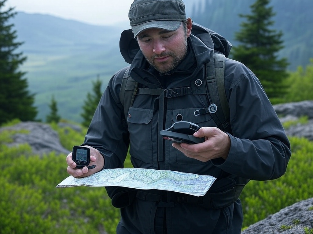
Combining GPS technology, satellite communicators, and map and compass skills creates a robust and comprehensive navigation and safety system for wilderness exploration. Each tool brings unique strengths to the table, and when used together, they complement each other to enhance safety, efficiency, and the overall experience. Let’s explore how these tools work in synergy to provide a well-rounded approach to wilderness navigation.
GPS Technology: Precision and Convenience
Precision Navigation
GPS devices offer unparalleled precision in navigation by providing real-time location data. They allow adventurers to pinpoint their exact coordinates, track their movements, and plan routes with accuracy. This precision is particularly valuable in complex terrains where maintaining an accurate course is crucial.
Route Planning and Tracking
With advanced route planning and tracking features, GPS devices enable users to pre-load maps, set routes, and receive continuous updates on their progress. This capability helps adventurers optimize their paths, conserve energy, and avoid unnecessary detours, making their journeys more efficient and enjoyable.
Satellite Communicators: Ensuring Communication
Reliable Communication in Remote Areas
Satellite communicators provide a reliable means of communication in areas without cellular coverage. By connecting to satellite networks, these devices allow users to send and receive messages, ensuring that they can stay in touch with the outside world even in the most isolated environments.
Emergency Response and Safety
Equipped with SOS functions, satellite communicators offer a critical lifeline in emergencies. They enable users to alert emergency services to their location, ensuring that help can be dispatched quickly and accurately. This feature is essential for addressing life-threatening situations and provides peace of mind for adventurers and their loved ones.
Map and Compass: Reliability and Independence
Independence from Technology
Map and compass skills offer a level of reliability that electronic devices cannot always guarantee. These tools do not rely on batteries or signals, making them dependable in situations where technology may fail. Understanding how to read a map and use a compass ensures that adventurers can navigate independently, regardless of technological limitations.
Enhancing Situational Awareness
Using a map and compass encourages adventurers to engage with their surroundings, enhancing situational awareness. This skill fosters a deeper understanding of the terrain and helps adventurers make informed decisions based on the landscape. It also promotes a greater connection with the natural environment, enriching the overall exploration experience.
Creating a Comprehensive Navigation and Safety System
Complementary Strengths
By combining GPS technology, satellite communicators, and map and compass skills, adventurers leverage the strengths of each tool. GPS provides precision and convenience, satellite communicators ensure reliable communication, and map and compass offer reliability and independence. Together, they form a comprehensive system that addresses the diverse challenges of wilderness navigation.
Building Redundancy and Resilience
Integrating these tools builds redundancy and resilience into wilderness exploration. If one tool fails, others can compensate, ensuring that adventurers are never left without navigation or communication options. This redundancy is crucial for managing unexpected challenges and enhances the overall safety and success of the journey.
Combining GPS technology, satellite communicators, and map and compass skills creates a comprehensive navigation and safety system that enhances wilderness exploration. By leveraging the strengths of each tool, adventurers can navigate with precision, communicate reliably, and maintain independence, ensuring a seamless and safer experience in the wild. This integrated approach empowers explorers to connect with nature while being well-prepared for the challenges they may encounter.
4.2 Building Redundancy and Resilience
Integrating GPS technology, satellite communicators, and map and compass skills into wilderness exploration creates a system of redundancy and resilience that is essential for managing the unpredictable nature of the wild. Each tool has its strengths and limitations, and by using them together, adventurers can ensure that they are prepared for a wide range of scenarios. Let’s explore how this integration builds redundancy and resilience, enhancing safety and adaptability in the wilderness.
Building Redundancy in Navigation
GPS Technology as the Primary Tool
GPS devices are often the primary navigation tool due to their precision and convenience. They provide real-time location data, route planning, and tracking capabilities, making them invaluable for maintaining an accurate course. However, GPS devices rely on batteries and satellite signals, which can be compromised in certain conditions.
Map and Compass as Reliable Backups
Map and compass skills serve as a reliable backup to GPS technology. Unlike electronic devices, they do not depend on power sources or signals, making them immune to technological failures. If a GPS device runs out of battery, loses signal, or malfunctions, a map and compass can take over, ensuring that adventurers can continue navigating effectively.
Ensuring Communication Redundancy
Satellite Communicators for Remote Communication
Satellite communicators provide a critical communication link in areas without cellular coverage. They enable users to send and receive messages and access emergency services, offering a lifeline in isolated environments. However, like GPS devices, they rely on power and satellite connectivity.
Traditional Signaling Methods
In the event that a satellite communicator fails, adventurers can fall back on traditional signaling methods, such as using mirrors, whistles, or signal fires, to attract attention. While these methods may not offer the same immediacy as electronic communication, they provide an additional layer of redundancy that can be crucial in emergencies.
Enhancing Resilience to Unexpected Challenges
Adapting to Environmental Conditions
The wilderness is inherently unpredictable, with rapidly changing weather, difficult terrain, and unexpected obstacles. By integrating multiple navigation and communication tools, adventurers can adapt to these conditions more effectively. For example, if dense foliage or deep canyons obstruct GPS signals, a map and compass can guide the way.
Managing Equipment Failures
Equipment failures are a common challenge in the wilderness, whether due to harsh conditions, user error, or technical malfunctions. Having multiple tools at one’s disposal ensures that a single failure does not compromise the entire expedition. This resilience allows adventurers to continue their journey with confidence, knowing they have alternative options.
Integrating GPS technology, satellite communicators, and map and compass skills builds redundancy and resilience into wilderness exploration. This comprehensive approach ensures that adventurers are never left without navigation or communication options, even in the face of unexpected challenges. By leveraging the strengths of each tool, explorers can navigate safely and effectively, adapting to the dynamic nature of the wild and enhancing their overall experience.
5. Practical Application and Training
5.1 Skill Development and Practice
To harness the full potential of GPS technology, satellite communicators, and map and compass skills, adventurers must develop proficiency in each tool. This requires a commitment to regular practice and training, ensuring that users are well-prepared to navigate and communicate effectively in the wilderness. Let’s explore the importance of developing these skills and the methods by which adventurers can build confidence and competence.
Developing Proficiency in GPS Technology
Understanding Device Functions
To effectively use a GPS device, adventurers must familiarize themselves with its functions and features. This includes understanding how to input waypoints, set routes, and interpret the device’s interface. Users should also learn how to manage battery life and troubleshoot common issues, such as signal loss or software glitches.
Practicing Route Planning and Tracking
Regular practice with route planning and tracking is essential for mastering GPS technology. Adventurers can start by planning short routes in familiar areas, gradually increasing complexity as they gain confidence. This practice helps users become adept at navigating with precision and making real-time adjustments based on their location data.
Mastering Satellite Communicator Use
Learning Communication Protocols
Proficiency with satellite communicators involves understanding how to send and receive messages, activate SOS functions, and share location data. Users should practice these functions in non-emergency situations to ensure they can operate the device confidently when needed.
Simulating Emergency Scenarios
To prepare for real emergencies, adventurers can simulate scenarios where they must use their satellite communicator to request assistance. This practice helps users become comfortable with the device’s emergency features and ensures they can respond quickly and effectively in critical situations.
Building Map and Compass Skills
Reading and Interpreting Topographic Maps
Developing map skills requires the ability to read and interpret topographic maps accurately. Adventurers should practice identifying contour lines, symbols, and scales, as well as visualizing the terrain based on map data. This skill is crucial for planning routes and understanding the landscape.
Practicing Compass Navigation
Using a compass effectively involves understanding its components and how to take accurate bearings. Adventurers should practice orienting the map, setting a course, and navigating to specific points using a compass. Field exercises in various terrains can help reinforce these skills and build confidence.
Training Courses and Field Exercises
Participating in Navigation Workshops
Navigation workshops and training courses offer structured learning opportunities for adventurers to develop their skills. These courses often cover the fundamentals of GPS, satellite communicators, and map and compass use, providing hands-on experience and expert guidance.
Engaging in Field Exercises
Field exercises are an excellent way to apply navigation skills in real-world settings. By practicing in diverse environments, adventurers can test their abilities, identify areas for improvement, and gain practical experience. These exercises also help build resilience and adaptability, preparing users for the challenges of wilderness exploration.
Developing proficiency in GPS technology, satellite communicators, and map and compass skills is essential for effectively combining these tools in wilderness navigation. Regular practice, training courses, and field exercises help adventurers build confidence and competence, ensuring they are well-prepared to navigate and communicate in the wild. By mastering these skills, explorers can enhance their safety, efficiency, and overall experience in the great outdoors.
5.2 Planning and Preparation
The successful integration of GPS technology, satellite communicators, and map and compass skills into wilderness exploration hinges on meticulous planning and preparation. Proper preparation not only enhances safety but also ensures a seamless and enjoyable experience. Let’s delve into the key aspects of planning and preparation that adventurers should consider before embarking on a wilderness adventure.
Ensuring Device Readiness
Charging and Power Management
Before setting out, adventurers must ensure that all electronic devices, such as GPS units and satellite communicators, are fully charged. It’s also wise to carry spare batteries or portable power banks to extend the devices’ operational time, especially on longer trips. Understanding the power consumption of each device and planning accordingly can prevent unexpected power shortages.
Device Functionality and Updates
Checking the functionality of devices is crucial. Users should verify that all features are working correctly and that the devices have the latest software updates. Updates often include important bug fixes and improvements that can enhance performance and reliability in the field.
Preparing Maps and Navigation Tools
Updating and Reviewing Maps
Maps should be up-to-date and relevant to the area being explored. Adventurers should review their maps to familiarize themselves with the terrain, identifying key features such as trails, water sources, and elevation changes. Carrying both digital and physical copies of maps provides redundancy in case of device failure.
Calibrating and Testing Compasses
Compasses should be calibrated and tested before departure to ensure accuracy. Adventurers should practice using their compass to take bearings and orient maps, reinforcing their skills and confidence in using this essential tool.
Familiarizing with the Terrain
Researching the Area
Understanding the terrain is a critical component of preparation. Adventurers should research the area they plan to explore, gathering information on the landscape, climate, and potential hazards. This knowledge helps in planning routes that account for elevation changes, weather conditions, and other environmental factors.
Identifying Key Landmarks
Identifying key landmarks on the map and in the field aids in navigation and situational awareness. Adventurers should note significant features such as peaks, valleys, and water bodies that can serve as reference points during their journey.
Planning for Safety and Contingencies
Establishing Communication Plans
A communication plan is essential for safety. Adventurers should inform someone of their itinerary, including expected check-in times and emergency contacts. Satellite communicators can be used to send regular updates, providing reassurance to those monitoring the trip.
Preparing for Emergencies
Preparation for emergencies involves packing essential gear such as first aid kits, emergency shelters, and signaling devices. Adventurers should also have a clear understanding of how to use their satellite communicator’s SOS function and be familiar with emergency procedures.
The successful integration of GPS technology, satellite communicators, and map and compass skills into wilderness exploration requires careful planning and preparation. By ensuring device readiness, preparing maps and navigation tools, familiarizing with the terrain, and planning for safety and contingencies, adventurers can enhance their safety and ensure a seamless experience. This thorough preparation empowers explorers to navigate the wilderness with confidence, allowing them to focus on the beauty and adventure of the natural world.
Conclusion
The integration of modern GPS technology, satellite communicators, and traditional map and compass skills represents a holistic approach to wilderness navigation and safety. Each tool brings unique strengths that, when combined, create a robust system capable of addressing the diverse challenges of exploring remote and rugged environments. Let’s explore how this comprehensive approach enhances the wilderness experience and prepares adventurers for any situation they may encounter.
Leveraging the Strengths of Each Tool
GPS Technology: Precision and Efficiency
GPS devices provide unparalleled precision in navigation, offering real-time location data and advanced route planning capabilities. This precision allows adventurers to navigate complex terrains with confidence, ensuring they stay on course and reach their destinations efficiently. The convenience of GPS technology reduces the cognitive load on explorers, allowing them to focus more on the experience rather than constantly worrying about their path.
Satellite Communicators: Reliable Communication
Satellite communicators ensure that adventurers can maintain communication even in the most isolated areas. By providing a direct link to emergency services and the ability to send and receive messages, these devices offer a critical safety net. This reliable communication is essential for coordinating with support teams, accessing real-time weather updates, and summoning help in emergencies, thereby enhancing overall safety.
Map and Compass: Reliability and Independence
Map and compass skills offer a level of reliability that electronic devices cannot always guarantee. These tools do not rely on batteries or signals, making them dependable in situations where technology may fail. Mastery of map and compass skills fosters independence, allowing adventurers to navigate confidently without relying solely on electronic aids. This independence is crucial for developing a deeper connection with the environment and enhancing situational awareness.
Enhancing Navigation Precision and Communication
Seamless Integration for Optimal Performance
By integrating these tools, adventurers can achieve optimal performance in navigation and communication. GPS technology provides the precision needed for accurate route planning, satellite communicators ensure reliable communication, and map and compass skills offer a backup system that enhances resilience. This seamless integration allows explorers to adapt to changing conditions and unexpected challenges with ease.
Building Resilience and Independence
The combination of these tools builds resilience by providing multiple layers of redundancy. If one tool fails, others can compensate, ensuring that adventurers are never left without navigation or communication options. This redundancy is crucial for managing the unpredictable nature of the wilderness, where conditions can change rapidly and unexpectedly. Additionally, the independence gained from mastering map and compass skills empowers adventurers to rely on their abilities, fostering confidence and self-reliance.
Preparing for Any Challenge
Comprehensive Preparation and Adaptability
The comprehensive approach to wilderness navigation and safety ensures that adventurers are well-prepared for any challenge they may encounter. By leveraging the strengths of each tool, explorers can anticipate potential obstacles, plan for contingencies, and adapt to changing conditions. This preparation enhances safety and allows adventurers to focus on the joy of exploration, knowing they are equipped to handle whatever the wilderness may present.
Enriching the Wilderness Experience
Ultimately, the integration of GPS technology, satellite communicators, and map and compass skills enriches the wilderness experience. It allows adventurers to explore with confidence, knowing they have the tools and skills necessary to navigate safely and effectively. This comprehensive approach not only enhances the technical aspects of navigation but also deepens the connection with the natural world, making each journey a more fulfilling and rewarding experience.
Combining modern GPS technology, satellite communicators, and traditional map and compass skills offers a comprehensive approach to wilderness navigation and safety. By leveraging the strengths of each tool, adventurers can enjoy a seamless and safer experience in the wild, building resilience and independence that prepare them for any challenges they may encounter.


Leave a Reply